Ahead of us were the infamous tidal flows of Darwin and its guardian Dundas and Clarence Straits, two or more days of irresistable rips and crucial tide timetables. For a clean run, one writer claimed that we needed to maintain an average speed of eight knots, which even allowing for a following current is a bit of an ask. Lugubrious cruising guides spoke of yachts that had mistimed it and anchored up, only to be sucked out of their safe bays by the marauding rip. On top of this, it’s the end of winter and we’re heading into the spring tides when the tides exceed nine metres and everything is just that little bit worse.
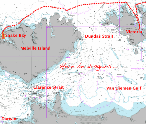
DUNDAS AND CLARENCE STRAITS (SCALE: 90 MILES)
Jimmy Cornell in his influential book ‘World Cruising Routes’ states quite bluntly that it should not be attempted, and recommends taking the longer route around Melville Island, even though this adds a hundred miles to the journey and ends with seventy miles of beating into wind to get to Darwin.
Even taking the northern route, cautious tidal planning is still necessary. We left Port Essington on a falling tide, hoping to get sucked out of the bay and at least half way across the entrance to the Dundas Strait before having to fight the easterly set. The plan began well, but inevitably we ended up in a hard slog against up to five knots of current. Luckily the trade winds were behind us and we could make a few knots of headway.
Evening fell as we fought free of the influence of the Strait, and then we had a hard nights sail across the top of Melville Island. The currents were increasingly difficult to predict and we zigzagged wildly. Even at the large scale of the chart above, you can see that our route was not exactly straight.
We sailed all night and most of the next day. We didn’t seen any other boats, but we did spot a bird floating along on the sea. You might not think that this was so strange, but the bird, apparently a black and white booby, was nonchalantly standing upright on the surface. As we got closer, we realised that it was standing on the back of a turtle that was nonchalantly swimming along. The pair were still together when they passed over the horizon.
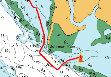
By mid afternoon we were entering Snake Bay. We knew nothing at all about this area apart from the fact that it was a north-facing river entrance that should give us protection from the south-easterly trades, and that the aboriginal community there had a broadband mast. We’d been out of touch for well over a week, and quite apart from updating this blog, we needed to check on our university work and deal with some business.
Snake Bay is divided into easterly and a westerly channels, and judging by the patterns of the sand banks on the chart it looked as if the eastern side would have less current. By the time we got there, though, the wind had shifted to the NE and was blowing straight at us, building up an uncomfortable chop. Aware that the charts only had a zone of confidence of C (“depth anomalies may be expected”), we crept further upstream looking for shelter, but found none.
It was time for Plan B. I had previously noted that it seemed to be just possible to squeeze through a 30 metre gap in the shoals and access the main western channel, before tackling a 30 metre wide bar between two drying banks which would drop us into a 5 metre deep pool inside a large drying mud lake.
In a nifty and stylish piece of navigation (I can safely say this in retrospect, since we didn’t hit anything) we arrived at the centre of the 100 metre square pool and dropped anchor in millpond smooth waters.
APPLAUSE!
After catching up with the outside world and sipping a G&T or two, we collapsed into bed for our first sleep in 48 hours. The wind shifted in the night, and blew ash and smoke from the aboriginal fires through the cabin. I imagine that it kept the mosquitoes away.