Rounding Cape York

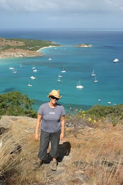
We had embarked on a four-day passage up through the Great Barrier Reef and out into the Torres Strait. The trade winds were blowing fairly consistently and the weather forecast was good. It was also stinking hot, and we discovered that some of our eggs had cooked themselves inside their shells.

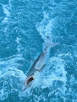
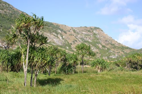
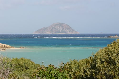
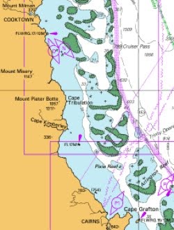
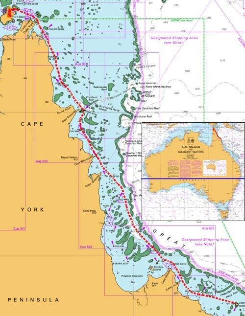
The Great Barrier Reef is much more than the outer ribbon reef that protects the eastern coastline from the open ocean. Inside the enclosed lagoon are tens of thousands of square miles of shallow water dotted by uncountable reefs and islands, many of them still uncharted. The reefs are mostly invisible and lurk just below the surface, so the only way that you can know where they are is to pay diligent attention to the charts.


LIZARD ISLAND TO CAPE YORK

I really have to take my hat off to Captain Cook who sailed these waters with no idea what lay beneath. It is a wonder that the Endeavour only suffered one serious accident here. Bligh also passed through in his open boat after having been set adrift by the mutineers on the Bounty. We passed a few of the islands that he stopped at on his epic journey from Tahiti to Indonesia, a feat that he achieved by navigating entirely from memory.

Those men were giants.

One thing that Bligh and Cook didn’t have to contend with were the ore freighters which continually forge their way up and down the coast. With a good chart, it is possible to thread a large vessel through the reefs in any number of ways, but the maritime authorities have now designated a few specific routes and have made it illegal for commercial vessels to stray from them. On the one hand, this guarantees safe passage for the ships without fear of encountering an unmarked reef, and it means that we always know where they are likely to be, and where they will be heading. On the other hand, the designated channel is often the only reasonable route through, creating pinch points where all vessels, commercial and private, must come together. This is especially exciting at night when you are tired and alone on deck and find that your fragile cockleshell is suddenly the focal point of three enormous cargo ships.


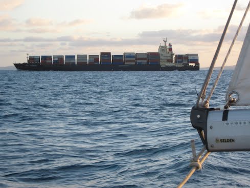
SHIPS THAT PASS IN THE NIGHT

We planned a route that largely avoided the shipping channels in the daytime, but which used them at night when we could take advantage of their navigation beacons.

The days passed and we settled into shipboard routine. The sailing was generally easy, although the trades tended to blow harder at night. In the day, they sometimes died right off, or we’d be hit by a squall, but we made good time and rounded Cape York at around three in the morning of the fourth day.


ROUNDING THE CAPE

Cape York is the northenmost tip of mainland Australia, and a milestone on our trip. It gave us an immense sense of achievement to have made it all the way up the east coast. We had now turned the corner, and from now on would be sailing into the sunset.

Big Fish

Coming abeam of Watson Island (where Mrs Watson’s body was found, see our previous blog), Bronwyn tossed out the trolling line to see if she could catch us a fish supper. Within half an hour or so, something struck hard. It fought mightily in the distance, but eventually Bronwyn managed to haul it in hand over hand so that we could get a look at it.

We realised that instead of catching dinner, we had hooked well over a metre of something that looked very much like a shark. It was muscular with a flattened body, brown above and white below, a wide mouth like a catfish, and big dorsal and pectoral fins. It wasn’t in any of our fish books, but it certainly didn’t look like anything that we wanted to share our cockpit with, so we decided to let it go.

The only problem was that it had swallowed our one and only trolling spoon, and we needed it back. For almost an hour, Bronwyn played the enormous beast back and forth, trying to tire it enough to get it close to the boat so that I could pull out the hook and let it go. We got so engrossed in the task that I forgot to look where we were going, and got a real shock when I checked our course over my shoulder and found that we were about to T-bone a sand island.

At that precise moment, the wind increased to 30 knots and stayed there, leaving me with only a tiny slot between the edge of the island and a 7-knot gybe. At the same time, the fish was experiencing a whole extra knot of speed, and Bronwyn’s shoulders were aching with the effort of keeping it with us.


NOT SUPPER

A few minutes later, with disaster averted, we pointed the boat into the (suddenly well-behaved) wind and then cursed as the big fish made a sprint under the boat. If it got the line wrapped around the propeller, we would never get it back. However, it seemed to know what it was doing, because the line went slack and the fish swam off, leaving our tackle behind and apparently only slightly exerted by several miles of hard fighting.

We decided to eat canned soup for dinner.

Lizard Island

We woke behind Cape Flattery to a weather forecast telling us to expect 30 knot winds again in the evening and all of the next day. We could have stayed there, but it was pretty dull and not very well insulated from the swell. Lizard Island beckoned from less than 20 miles away, giving us ample time to get there and hide before the blow started again.

When we poked our nose out from behind Cape Flattery, we found a reasonable 20-25 knots which took us to Lizard in no time at all.

We’d heard good reports of the island and were keen to stay for a while to explore. When we arrived at the Mrs Watsons Bay anchorage, we were a little surprised to find more than a dozen cruising boats packed in among the coral heads, as well as a fair sized but inconspicuous resort on the shore.


ROOM FOR ONE MORE?


PINDIMARA AT THE EDGE OF THE REEF

The bay is named after the eponymous wife of a beche-de-mere fisherman who was attacked there by aboriginals while her husband was out fishing. She and a servant and her newborn child escaped to sea in a cast iron boiling tub, and eventually washed up on what is now called Watson Island, where all three of them perished.

The water was blue and crystal clear; we could actually see the anchor on the bottom. The island gave good protection from the developing swell, but very little from the actual wind, so we put out all 70 metres of chain in preparation for the night ahead.

It did indeed blow that night, 30 knots or more, and all the boats got a good thrashing. I kept being awoken by strange sounds that had me running up on deck, but the anchor held. We were a bit tired the next morning, and simply stayed below all day as the wind continued to howl.

The next night was a little calmer, and by lunchtime the waves had died down enough that we were finally able to lower to outboard into the tender and go ashore.

We found a trail leading across the island and through the Pandanus swamps that fill the level ground between the rocky hills.


OFF INTO THE MANGROVES


PANDANUS SWAMP


LOCAL BEACHCOMBER

The trail led to the ‘Blue Lagoon’, an unusual geological formation in that coral lagoons are usually features of reef rather than of continental islands. In the case of Lizard Island it also provides yacht anchorage in calm weather, but those conditions certainly didn’t apply today and nobody had tried it.


THE BLUE LAGOON

There were, however, a few kite-surfers playing around, having sailed around the island from the resort.


JUST PASSING THROUGH

Lizard Island is also famous for having a peak that was climbed by Captain Cook when he was trying to find a vantage point from which he could plan a way out of the Great Barrier Reef. We set off on his trail on the following morning. It was a pleasant clamber over enormous granite boulders, shaded here and there by gums, and the views down into the reefs of Mrs Watsons Bay were spectacular.

BRONWYN AND MRS WATSON THE WAY TO COOKS LOOK

From the top of the hill, we could faintly make out in the distance the dark blue of lurking ribbon reef, and the lighter blue of safe passages. If Cook hadn’t successfully spotted the gap, then he might not have made it back to England and Australians today might all be speaking French. It was very satisfying to stand there on a hilltop on an island in the far Great Barrier Reef, staring out to sea and feeling the connection to the history of our adopted country. Bien sûr.

Back at shore level, we went for a welcome swim in the gloriously clear water, and used the coral sand to scrub away the weeks of sun tan lotion and grime before returning to Pindimara for a rare and welcome freshwater shower.

We’ll definitely be coming back to Lizard Island again. It has genuinely beautiful white coral beaches, a very pretty landscape, some serious rocks, and a warm and easily accessible reef. Wonderful.

But now, it’s time to move on. The Torres Strait beckons.


WE GO THATAWAY!

Entering the Great Barrier Reef

For all that we’ve technically been sailing inside the Great Barrier Reef for several weeks, the reef itself has always been invisibly far out to sea. From here northward, though, the Barrier comes close inshore and is a navigational force to be reckoned with, comprising hundreds of scattered reefs lurking invisibly just below the waves. There is a well-charted and waymarked shipping channel to ease navigation, but it is full of large ships moving ore and containers up and down the coast.


THE NEXT HUNDRED MILES OF REEF

After weeks of dead calm, we’d been wishing for a breeze. Dusk fell, a humpback whale treated us to an aerial display in our wake, and – wonder of wonders – the wind picked up to the low twenties. Our speed increased to 6-7 knots under full sail as we entered the channel. Harriet was doing a fine job of sailing, so while Bronwyn went below to rest, I was free to sit in comfort and idly formulate an elaborate metaphor for the process of sailing through the reef at night.

Imagine getting into your car to drive to the next town. First, however, you spray-paint the windows black so that you can’t see out. Then you tape your mobile phone to the dashboard and log on to Google Maps. You start the engine and put it into gear, and from now on you are completely at the mercy of the accuracy of the map and where your phone says that you are.
You can be reasonably certain that all the streets and intersections are marked, as well as the more obvious light poles and roadside furniture, but you just have to deal with curbs, speed humps, rubbish bins, dogs and cats as you feel your wheels bump over them.
Thankfully there is little other traffic, but you know that if you leave these twisting side-roads and venture onto the highway, you will be sharing the road with fully laden trucks. You also know that they can’t see you either, and that in any case all their brake lines have been disconnected.

As I lay in the cockpit spinning this tale and watching meteorites blaze across the milky brilliance of the starry sky, Pindimara ploughing blindly into pitch darkness at close to hull speed, I thought happily that I wouldn’t trade places with anybody.

The hours passed, and the wind crept up to the mid twenties. Pindimara was now quite overpowered, but there were few gusts and the swells were predictable, so I left the sails up. Harriet the Hydrovane was coping superbly, and tracking better than ever before; I was really coming to appreciate the Hydrovane slogan ‘survive your dream’.

In the early hours of the morning, deep inside the shipping lane with bulk carriers and trawlers passing on either side, the wind crept up into the high twenties and our speed to over seven knots. It was getting decidedly bouncy, so I reckoned that enough was enough and called all hands on deck to reduce sail. To say that the crew tumbled eagerly out of their bunks would be an overstatement, and when Bronwyn did clamber painfully out, she commented that her ‘rest period’ in the bucking bunk seemed to have consisted mainly of two hours of strenuous but inadvertent Pilates exercise.

We quickly reduced sail and got back onto course. As is our usual practice on night passages, we’d gone straight for the main’s third reef, but Harriet soon picked up the pace to a respectable 4-5 knots. I was pretty tired by now so I gratefully put my head down while Bronwyn took a watch.

At a little after 4am I took over again, and immediately got my feet wet as a wave curled over the stern. The swell was now well over 2 metres, and the wind was touching 30 knots. It had also swung around onto the beam, and even with the third reef in, we were overpowered for a reach. The wind was howling in the rigging, and the hull was thrumming and making odd little banging sounds under my feet. We were stll four hours from the safe harbour at Lizard Island, and I seriously considered replacing the main with our storm trysail for the final leg. Instead I chose discretion, and put our tail between our legs and ran for nearby Cape Flattery, which at 260 metres high looked to be big enough to hide behind.

The wind was easier to manage with it behind us, but the wind speed continued to increase and of course we were now surfing down 3 metre swells in the darkness. As the Cape loomed out of the gathering dawn light, I once again roused Bronwyn who navigated us in to shelter between the Cape itself and the chart position of a sunken wreck.

Anchoring for once in the light, we immediately fell into bed and slept until lunch time. Although we were snug in our bay, the 30-knot wind continues to howl over our heads.

Be careful what you wish for.